


وصف لـ Handy GPS (free)
The perfect companion for your next outdoor adventure. Seek, find, record and return home with Handy GPS. No user account or setup required - just install it, turn on your GPS and go!
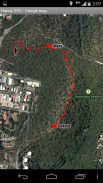
This app is a powerful navigation tool designed for outdoors sports like hiking, bushwalking, tramping, mountain biking, kayaking, horse trail riding, and geocaching. Its also useful for surveying, mining, archaeology, and forestry applications. Its simple to use and works even in the remotest back country since it doesn't require network connectivity. It allows you to work in UTM or lat/lon coordinates so you can even use it with your paper topographic maps. Waypoints and track logs recorded in the field can be be viewed later in Google Earth.
NOTE: This is a free trial version and is limited to storing only 3 waypoints, and 40 track log points. You can use the trial version for as long as you want, but if you like this app, please install the paid version of "Handy GPS" to get an unlimited version with lots more features. Thanks!
BASE FEATURES:
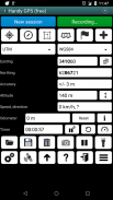
* Shows your current coordinates, altitude, speed, direction of travel, and total distance travelled in metric, imperial/US, or nautical units.
* Can store your current location as a waypoint, and record a track log to show where you've been on a map.
* Data can be imported from and exported to Google Earth KML and GPX files.
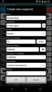
* Allows manual entry of waypoints in UTM, MGRS and lat/lon coords.
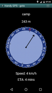
* Can guide you to a waypoint using the "Goto" screen, and optionally sound an alert when when you're getting close.
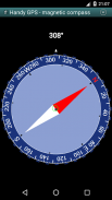
* Has a compass page which works on devices with magnetic field sensors.
* Automatically computes the local geoid offset to improve altitude accuracy
* Supports the world-wide WGS84 datum along with the common Australian datums and map grids. You can use WGS84 for NAD83 maps in the US.
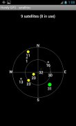
* Shows GPS satellite locations and signal strengths graphically.
* Can display simple or MGRS grid references.
* Can compute waypoint-to-waypoint distance and direction.
* Includes an optional timer line to record walk duration and compute your average speed.
* If you have an Android Wear smartwatch, a stand-alone watch version of the app will also be installed. (The free Wear version is limited to storing 1 waypoint).
* Thoroughly tested by the developer on many off-track walks
EXTRA FEATURES ONLY IN THE PAID VERSION:
* No ads.
* An unlimited number of waypoints and track log points.
* Offline maps.
* Custom datums.
* Elevation profile.
* Take photos and record voice memos from the app.
* Email or SMS your location to a friend.
* UK grid refs.
* GPS averaging to improve location accuracy,
* Sun rise and set times.
* Export waypoints and tracklogs to a CSV file.
* Project waypoints using bearing and distance.
* Compute length, area, and elevation change from the tracklog.
* Compute calories.
PERMISSIONS: (1) GPS - to determine your location, (2) Network access - for access to Google Map and OSM tiles, (3) SD card access - to load and store waypoints and tracklogs, (4) Camera access for taking pics*, (5) Prevent phone from sleeping so that proximity alarm works, (6) Control flashlight, to allow the flashlight to be turned on/off from within the app, (7) System settings, to allow the Android Wear app to control the watch screen brightness, (8) Record audio for voice memos*. (* Feature only available in full version of app).
Disclaimer: You use this app at your own risk. The developer accepts no responsibility for you getting lost or injured as a result of using this app. Batteries in mobile devices can go flat. An alternate power source is recommended for extended hikes.
Versions of this app are also available for iPhones and Windows Phones.
الرفيق المثالي لمغامرك القادمة في الهواء الطلق. يمكنك البحث عن المنزل وتسجيله وإعادته والعودة إليه باستخدام نظام تحديد المواقع العالمي (Handy GPS). لا يتطلب أي حساب مستخدم أو إعداد - فقط قم بتثبيته ، قم بتشغيل GPS الخاص بك وانتقل!
هذا التطبيق هو أداة تنقل قوية مصممة للرياضة في الهواء الطلق مثل المشي لمسافات طويلة ، والمشي في الأدغال ، والقفز ، وركوب الدراجات الجبلية ، والتجديف ، وركوب الخيل وركوب الخيل ، وجيوكاشينغ. انها مفيدة أيضا لعمليات المسح ، والتعدين ، والآثار ، والحراجة. إنه سهل الاستخدام ويعمل حتى في أقصى المناطق البعيدة لأنه لا يتطلب اتصالاً بالشبكة. يسمح لك بالعمل في إحداثيات UTM أو lat / lon حتى يمكنك استخدامه مع خرائط الطبوغرافيا الورقية. يمكن الاطلاع على نقاط الطريق وسجلات المسارات المسجلة في الحقل لاحقًا في Google Earth.
ملاحظة: هذا هو نسخة تجريبية مجانية ، ويقتصر تخزين 3 نقاط الطريق فقط ، و 40 نقطة سجل المسار. يمكنك استخدام الإصدار التجريبي طالما تريد ، ولكن إذا كنت تحب هذا التطبيق ، يرجى تثبيت النسخة المدفوعة من "Handy GPS" للحصول على إصدار غير محدود مع الكثير من الميزات. شكر!
ميزات قاعدة:
* يعرض الإحداثيات الحالية الخاصة بك ، والارتفاع والسرعة واتجاه السفر ، والمسافة الإجمالية سافر في وحدات متري ، إمبراطوري / الولايات المتحدة ، أو البحرية.
* يمكن تخزين موقعك الحالي كنقطة الطريق ، وتسجيل سجل المسار لإظهار أين كنت على الخريطة.
* يمكن استيراد البيانات وتصديرها إلى ملفات Google Earth KML و GPX.
* يسمح الإدخال اليدوي لنقاط الطرق في UTM ، MGRS والاسلاك اللات / لون.
* يمكن أن يرشدك إلى نقطة الطريق باستخدام شاشة "Goto" ، وبصوت اختياري تنبيه عندما تقترب.
* يحتوي على صفحة بوصلة تعمل على أجهزة مزودة بمجسات المجال المغناطيسي.
* يحسب تلقائيا إزاحة الجيود المحلية لتحسين دقة الارتفاع
* يدعم مسند WGS84 في جميع أنحاء العالم جنبا إلى جنب مع المشابك الأسترالية وشبكات الخريطة العامة. يمكنك استخدام WGS84 لخرائط NAD83 في الولايات المتحدة.
* يعرض مواقع الأقمار الصناعية GPS وقوة الإشارة بيانيا.
* يمكن عرض مراجع الشبكة بسيطة أو MGRS.
* يمكن حساب نقطة الطريق إلى اتجاه الطريق والإتجاه.
* يتضمن خطًا مؤقتًا اختياريًا لتسجيل مدة السير وحساب متوسط السرعة.
* إذا كان لديك ساعة ذكية لـ Android Wear ، فسيتم أيضًا تثبيت إصدار ساعة مستقل للتطبيق. (يقتصر الإصدار المجاني من Wear على تخزين نقطة إحداثية واحدة).
* اختبار شامل من قبل المطور على العديد من مناحي خارج المسار
ميزات اضافية فقط في النسخة المدفوعة:
* لا اعلانات.
* عدد غير محدود من نقاط الطريق ونقاط سجل المسار.
* الخرائط دون اتصال.
* مخصص مساند.
* ملف تعريف الارتفاع.
* التقاط الصور وتسجيل المذكرات الصوتية من التطبيق.
* البريد الإلكتروني أو SMS موقعك إلى صديق.
* المرجع شبكة المملكة المتحدة.
* متوسط GPS لتحسين دقة الموقع ،
* ارتفاع الشمس ومرات.
* نقاط الطريق للتصدير و tracklogs إلى ملف CSV.
* نقاط الطريق المشروع باستخدام تحمل والمسافة.
* حساب الطول والمساحة ، وتغيير الارتفاع من trackTrack.
* حساب السعرات الحرارية.
الأذونات: (1) GPS - لتحديد موقعك ، (2) الوصول إلى الشبكة - للوصول إلى خريطة جوجل والبلاط OSM ، (3) الوصول إلى بطاقة SD - لتحميل وتخزين نقاط الطريق و tracklogs ، (4) وصول الكاميرا لأخذ بلدان جزر المحيط الهادئ * ، (5) منع الهاتف من النوم بحيث يعمل التنبيه التقريبي ، (6) مصباح يدوي للتحكم ، للسماح بتشغيل / إيقاف تشغيل مصباح يدوي من داخل التطبيق ، (7) إعدادات النظام ، للسماح لتطبيق Android Wear بالتحكم سطوع شاشة العرض ، (8) تسجيل الصوت للمذكرات الصوتية *. (* الميزة متوفرة فقط في الإصدار الكامل من التطبيق).
تنويه: يمكنك استخدام هذا التطبيق على مسؤوليتك الخاصة. المطور لا يتحمل أي مسؤولية عن ضياعك أو جرحك نتيجة لاستخدام هذا التطبيق. يمكن أن تصبح البطاريات في الأجهزة المحمولة ثابتة. ينصح باستخدام مصدر طاقة بديل للمشي لمسافات طويلة.
تتوفر إصدارات هذا التطبيق أيضًا لهواتف iPhone و iPhone.
Handy GPS (free) - إصدار 41.3
(15-09-2023)
Handy GPS (free) - معلومات APK
نُسخة APK: 41.3الحزمة: binaryearth.handygpsfreeتطبيقات من الفئة نفسها
قد يعجبك أيضًا...


